
Berkas:Kassite Babylonia EN.svg

Ukuran pratayang PNG ini dari berkas SVG ini: 661 x 580 piksel Resolusi tanö bö'ö: 274 x 240 piksel | 547 x 480 piksel | 875 x 768 piksel | 1.167 x 1.024 piksel | 2.334 x 2.048 piksel.
Berkas si föföna sibai (Berkas SVG, 661 x 580 piksel, fa'ebua berkas: 183 KB)
Furugönia
| Fanutunö |
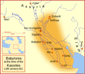
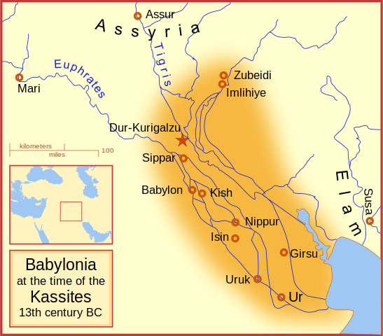
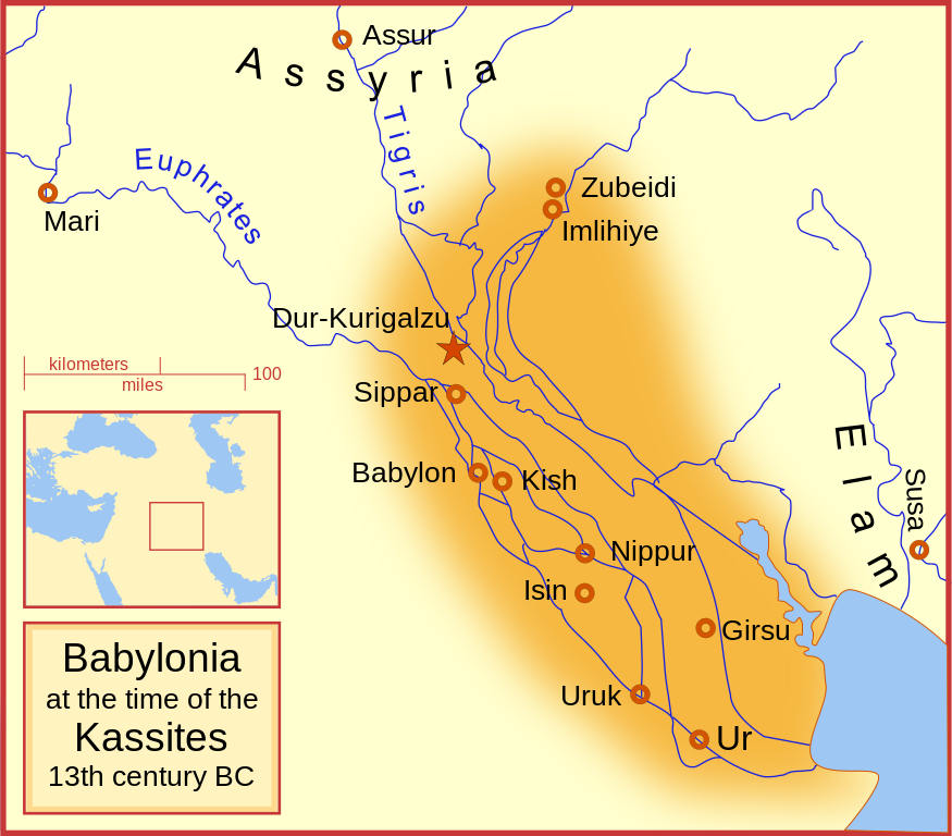
English: A map of the Babylonian Empire during the time of the Kassites, roughly the 13th century BC. This map shows the probable river courses and coastline at that time. Català: Babilònia durant la dinastia cassita (s. XIII aC) |
|||||
| Baŵa | ||||||
| Kode | Nifazökhigu samösa | |||||
| Sanura | MapMaster | |||||
| Versi lainnya |
File:Kassite Babylonia EN.svg has 5 translations.
|


Other versions
Similar maps
References
- Roaf, M. (1990) Cultural Atlas of Mesopotamia and the ancient Near East, Oxford: Facts on File. (In general, the basis for the ancient river courses and ancient coastline).
Lisensi
Saya, pemilik hak cipta dari karya ini, dengan ini menerbitkan berkas ini di bawah ketentuan berikut:

|
Tetehegö wangai, wame'e ma wamulö'ö dokumen andre faoma Lisensi Dokumentasi Bebas GNU, Versi 1.2 ma zui sabölö afuria nifataro Free Software Foundation; lö Seksi Invarian, lö teks uli föna, ba lö teks uli furi. Kopi lisensi no tefaogö ba waosatö sotöi Lisensi Dokumentasi Bebas GNU. |
This file is licensed under the Creative Commons Attribution-Share Alike Attribution-Share Alike 4.0 International, 3.0 Unported, 2.5 Generic, 2.0 Generic and 1.0 Generic license.
- Tola ölau:
- fa'ohe'ö – wo-kopi, distribusi ba transmisi mbua halöŵö
- mamaruka – mamulö'ö ba mamazökhi zibohou moroi ba halöŵö andre
- Molo'ö kondisi andre:
- atribusi – Si lö tola lö'ö ösura kredit, khai-khai silalö ba lisensi ba ombakha'ö na so nifabö'öni. Tola ölau ia molo'ö fangera-ngerau, ba hiza böi sura wa no ifarou ndra'ugö sololohe lisensi.
- fa'ohe'ö – Na öbulö'ö ba öfazikhi zi bohou moroi ba halöŵö andre, si lö tola lö'ö öbe'e kontribusimö faoma same or compatible license simane lisensi halöŵö asli.
Fili lisensi somasi'ö
Waö-waö berkas
Höndrögö ba mbaŵa/ginötö wamaigi hewisa berkas ba ginötö andrö
| Baŵa/Inötö | Khala-khala berkas | Su'a-su'a | Sangoguna'ö | Komentar | |
|---|---|---|---|---|---|
| fondrege bohou | 20 September 2023 13.54 | | 661 × 580 (183 KB) | Jaumellecha | File uploaded using svgtranslate tool (https://svgtranslate.toolforge.org/). Added translation for ca. |
| 4 Maret 2008 00.39 |  | 661 × 580 (177 KB) | MapMaster | {{Information |Description=A map of the Babylonian Empire during the time of the Kassites, roughly the 13th century BC |Source=self-made |Date=3 March 2008 |Author= MapMaster |Permission= |other_versions= }} |
Fangoguna'ö berkas
Te'oguna'ö ba nga'örö andre berkas:
Fangoguna'ö berkas global
Wiki tanö bö'ö sangoguna'ö berkas andre
- Fangoguna'ö ba ar.wikipedia.org
- Fangoguna'ö ba azb.wikipedia.org
- Fangoguna'ö ba az.wikipedia.org
- Fangoguna'ö ba be.wikipedia.org
- Fangoguna'ö ba bg.wikipedia.org
- Fangoguna'ö ba br.wikipedia.org
- Fangoguna'ö ba ca.wikipedia.org
- Fangoguna'ö ba ceb.wikipedia.org
- Fangoguna'ö ba ckb.wikipedia.org
- Fangoguna'ö ba cs.wikipedia.org
- Fangoguna'ö ba cv.wikipedia.org
- Fangoguna'ö ba de.wikipedia.org
- Fangoguna'ö ba en.wikipedia.org
- Babylonia
- Kassites
- Amarna Period
- List of conflicts in Asia
- Kassite dynasty
- Middle Babylonian period
- User:SomeGuyWhoRandomlyEdits/List of conflicts in the Near East
- Renaissance of Sumer
- User:A.X.Wiki.Editor/Middle Babylonian period
- User:A.X.Wiki.Editor/List of conflicts in Iraq
- User:SomeGuyWhoRandomlyEdits/Kassite dynasty
- Fangoguna'ö ba en.wikibooks.org
- Fangoguna'ö ba fa.wikipedia.org
- Fangoguna'ö ba fa.wikibooks.org
- Fangoguna'ö ba fi.wikipedia.org
- Fangoguna'ö ba fr.wiktionary.org
- Fangoguna'ö ba he.wikipedia.org
- Fangoguna'ö ba hr.wikipedia.org
Faigi more global usage berkas andre.