
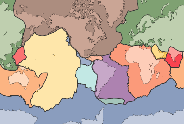
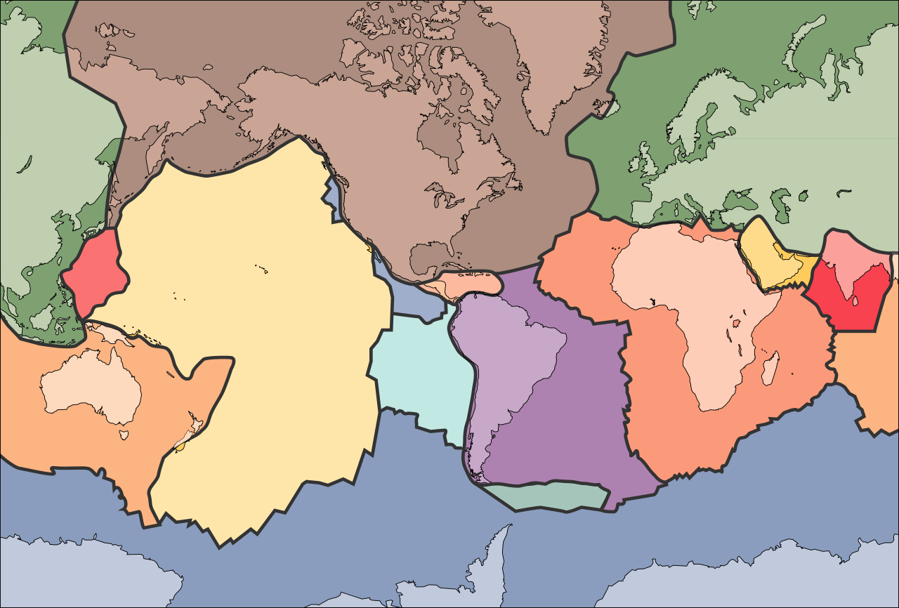
Berkas:Tectonic plates (empty).svg

Ukuran pratayang PNG ini dari berkas SVG ini: 681 x 461 piksel Resolusi tanö bö'ö: 320 x 217 piksel | 640 x 433 piksel | 1.024 x 693 piksel | 1.280 x 866 piksel | 2.560 x 1.733 piksel.
Berkas si föföna sibai (Berkas SVG, 681 x 461 piksel, fa'ebua berkas: 356 KB)
الخلافه الرشيديهkp
Furugönia
| Fanutunö | |
| Baŵa | 10 September 2005 (upload date) |
| Kode | File:Tectonic plates (empty).png |
| Sanura | Ævar Arnfjörð Bjarmason |
| Versi lainnya |
This file was derived from: Tectonic plates (empty).png:
[]
|
| SVG genesis | W3C-tidak sah Gambar vektor ini dibuat menggunakan Adobe Illustrator, and with Inkscape. |


.png)


.svg)
.png)
Lisensi
Gambar ini berada di domain umum di Amerika Serikat karena gamabar ini hanya mengandung bahan yang asli berasal dari Survei Geologi Amerika Serikat, sebuah badan Departemen Dalam Negeri Amerika Serikat. Untuk informasi lebih lanjut, lihat kebijakan hak cipta Survei Geologi Amerika Serikat resmi.
|
Waö-waö berkas
Höndrögö ba mbaŵa/ginötö wamaigi hewisa berkas ba ginötö andrö
| Baŵa/Inötö | Khala-khala berkas | Su'a-su'a | Sangoguna'ö | Komentar | |
|---|---|---|---|---|---|
| fondrege bohou | 11 Oktober 2006 09.04 | | 681 × 461 (356 KB) | Sting | Borders correction integrated to the continents borders; size of picture |
| 10 Oktober 2006 23.29 |  | 682 × 462 (285 KB) | Rogilbert~commonswiki | correction de frontières 2 | |
| 10 Oktober 2006 23.14 |  | 682 × 462 (212 KB) | Rogilbert~commonswiki | correction des frontière | |
| 10 September 2005 20.48 |  | 682 × 462 (199 KB) | Ævar Arnfjörð Bjarmason | SVG version of Image:Tectonic plates (empty).png {{PD-USGov-USGS}} Category:Plate tectonics |
.png)
Fangoguna'ö berkas
Lö nga'örö sangoguna'ö berkas andre
Fangoguna'ö berkas global
Wiki tanö bö'ö sangoguna'ö berkas andre
- Fangoguna'ö ba ar.wikipedia.org
- Fangoguna'ö ba az.wikipedia.org
- Fangoguna'ö ba bn.wikipedia.org
- Fangoguna'ö ba en.wikipedia.org
- Earth
- Internal structure of Earth
- Wikipedia:Graphics Lab/Image workshop/Archive/Jan 2009
- User:AvionArchon/sandbox
- User:Darth Tacker/TWA/Earth
- User:CheChe/Spoken Script
- User:Zanygenius/TWA/Earth
- User:Zanygenius/TWA/Earth/2
- User:Google7722/TWA/Earth
- Portal:Geophysics
- Portal:World
- User:FreshYoMama/TWA/Earth
- User:FreshYoMama/TWA/Earth/2
- Fangoguna'ö ba en.wikiversity.org
- Fangoguna'ö ba eo.wikipedia.org
- Kontinento
- Platotektoniko
- Litosfero
- Tektona plato
- Ŝablono:Tektonaj platoj
- Antarkta plato
- Eŭrazia plato
- Nordamerika plato
- Sudamerika plato
- Afrika plato
- Pacifika plato
- Hindia plato
- Aŭstralia plato
- Plato Nazca
- Anatolia plato
- Arabia plato
- Filipina plato
- Kokosa plato
- Karibia plato
- Plato Juan de Fuca
- Hind-Aŭstralia Plato
- Fangoguna'ö ba es.wikipedia.org
- Fangoguna'ö ba fa.wikipedia.org
- Fangoguna'ö ba fr.wikipedia.org
- Fangoguna'ö ba gl.wikipedia.org
- Fangoguna'ö ba hu.wikipedia.org
- Fangoguna'ö ba id.wikipedia.org
- Fangoguna'ö ba io.wikipedia.org
Faigi more global usage berkas andre.
.svg)
.svg)