
Berkas:Possible definitions of the boundary between Europe and Asia.png
Berkas si föföna sibai (729 x 1.129 piksel, fa'ebua berkas: 207 KB, tipe MIME: image/png)
Furugönia
| Fanutunö |
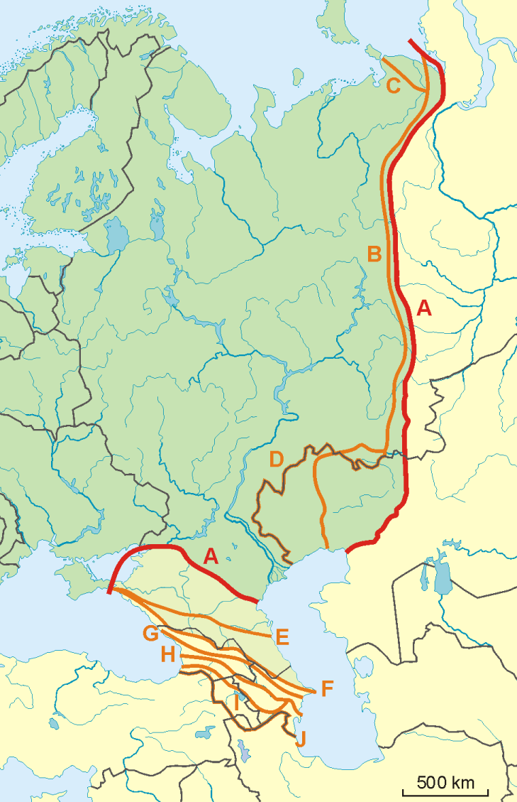
English: A map of possible definitions of the boundary between Asia and Europe.
Note that most of these lines are not referenced to any sources proposing them. The red line marked "A" is apparently the "Strahlenberg" definition commononly taught in Soviet-era Russia. See File:Historical Europe-Asia boundaries 1700 to 1900.png for a map which is actually based on references. The modern mainstream definition used by the UN (see also this) are marked "B" (Urals and Ural River) and "F" (Caucasus watershed). Lines C, D, E, G, H, I and J are currently without reference. Red line - "Strahlenberg" border, allegedly also used by the International Geographical Union [1]
Orange lines - other variants of border:
Polski: Mapa wariantów przebiegów granicy pomiędzy Europą a Azją
linie pomarańczowe - inne warianty przebiegu granicy:
|
| Baŵa | 09-04-2008 |
| Kode | Nifazökhigu samösa |
| Sanura | Aotearoa |
| Versi lainnya | Image:TransAsia m.png, File:Historical Europe-Asia boundaries 1700 to 1900.png |
Lisensi

|
Tetehegö wangai, wame'e ma wamulö'ö dokumen andre faoma Lisensi Dokumentasi Bebas GNU, Versi 1.2 ma zui sabölö afuria nifataro Free Software Foundation; lö Seksi Invarian, lö teks uli föna, ba lö teks uli furi. Kopi lisensi no tefaogö ba waosatö sotöi Lisensi Dokumentasi Bebas GNU. |
- Tola ölau:
- fa'ohe'ö – wo-kopi, distribusi ba transmisi mbua halöŵö
- mamaruka – mamulö'ö ba mamazökhi zibohou moroi ba halöŵö andre
- Molo'ö kondisi andre:
- atribusi – Si lö tola lö'ö ösura kredit, khai-khai silalö ba lisensi ba ombakha'ö na so nifabö'öni. Tola ölau ia molo'ö fangera-ngerau, ba hiza böi sura wa no ifarou ndra'ugö sololohe lisensi.
- fa'ohe'ö – Na öbulö'ö ba öfazikhi zi bohou moroi ba halöŵö andre, si lö tola lö'ö öbe'e kontribusimö faoma same or compatible license simane lisensi halöŵö asli.
Waö-waö berkas
Höndrögö ba mbaŵa/ginötö wamaigi hewisa berkas ba ginötö andrö
| Baŵa/Inötö | Khala-khala berkas | Su'a-su'a | Sangoguna'ö | Komentar | |
|---|---|---|---|---|---|
| fondrege bohou | 14 November 2022 15.34 | | 729 × 1.129 (207 KB) | Рагин1987 | Dull shade of green up to the "F" line |
| 19 Februari 2022 20.12 |  | 729 × 1.129 (205 KB) | Lojwe | Frame removed | |
| 2 Oktober 2010 03.29 |  | 735 × 1.134 (156 KB) | Bogomolov.PL | Reverted to version as of 08:57, 9 April 2008 | |
| 2 Oktober 2010 02.44 |  | 735 × 1.134 (137 KB) | Zé Carioca~commonswiki | Trying to fix the error we are facing on the articles. | |
| 1 Oktober 2010 22.56 |  | 735 × 1.134 (137 KB) | Gvogas | Inclusion of the Miles Clark route line. (sorry for the tries, my internet gave problems). | |
| 1 Oktober 2010 22.55 |  | 735 × 1.134 (137 KB) | Gvogas | Reverted to version as of 15:52, 1 October 2010 | |
| 1 Oktober 2010 22.54 |  | 735 × 1.134 (137 KB) | Gvogas | (Inclusion of the Miles Clark route line.) | |
| 1 Oktober 2010 22.52 |  | 735 × 1.134 (137 KB) | Gvogas | Inclusion of the Miles Clark route line. | |
| 9 April 2008 15.57 |  | 735 × 1.134 (156 KB) | Aotearoa | {{Information |Description=Map of Europe (green) - Asia (yellow) border. Red line (A) - border accoring to International Geographical Union and most European geographers, orange lines - other variants of border. |Source=własna praca |Date=09-04-2008 | |
Fangoguna'ö berkas
Te'oguna'ö ba nga'örö andre berkas:
Fangoguna'ö berkas global
Wiki tanö bö'ö sangoguna'ö berkas andre
- Fangoguna'ö ba am.wikipedia.org
- Fangoguna'ö ba ar.wikipedia.org
- Fangoguna'ö ba arz.wikipedia.org
- Fangoguna'ö ba az.wikipedia.org
- Fangoguna'ö ba ba.wikipedia.org
- Fangoguna'ö ba be.wikipedia.org
- Fangoguna'ö ba bn.wikipedia.org
- Fangoguna'ö ba ca.wikipedia.org
- Fangoguna'ö ba ce.wikipedia.org
- Fangoguna'ö ba cs.wikipedia.org
- Fangoguna'ö ba de.wikipedia.org
- Eurasien
- Portal:Mauern und Grenzen
- Liste interkontinentaler Staaten
- Wikipedia Diskussion:WikiProjekt Geographie/Archiv/2013-1
- Wikipedia:Löschkandidaten/28. Februar 2016
- Wikipedia Diskussion:WikiProjekt Kategorien/Archiv/2016-II
- Wikipedia Diskussion:Kurier/Archiv/2017/10
- Vorlage Diskussion:Navigationsleiste Kraftwerke
- Wikipedia Diskussion:Kurier/Archiv/2022/08
- Fangoguna'ö ba en.wikipedia.org
- Fangoguna'ö ba et.wikipedia.org
- Fangoguna'ö ba hr.wikipedia.org
- Kategorija:Arktičkooceanski slijev (Europa)
- Kategorija:Arktičkooceanski slijev (Azija)
- Kategorija:Mora Arktičkog oceana
- Kategorija:Reljefni oblici u Arktičkom oceanu
- Kategorija:Mora Arktičkog oceana (Azija)
- Kategorija:Mora Arktičkog oceana (Europa)
- Kategorija:Reljefni oblici u Arktičkom oceanu (Azija)
- Kategorija:Tjesnaci Arktičkog oceana (Europa)
- Kategorija:Vodene mase Arktičkog oceana (Europa)
- Kategorija:Reljefni oblici u Arktičkom oceanu (Europa)
- Kategorija:Tjesnaci Arktičkog oceana (Azija)
- Kategorija:Vodene mase Arktičkog oceana (Azija)
- Kategorija:Karsko more
- Predložak:Granica Europe i Azije
- Kategorija:Zaljevi Arktičkog oceana (Azija)
- Kategorija:Zaljevi Arktičkog oceana (Europa)
- Kategorija:Estuariji Arktičkog oceana (Azija)
- Kategorija:Estuariji Tihog oceana (Azija)
- Fangoguna'ö ba hu.wikipedia.org
- Fangoguna'ö ba hy.wikipedia.org
Faigi more global usage berkas andre.